Czechoslovakia was occupied by Nazi Germany in 1938–45 and
was under Soviet domination from 1948 to 1989. On January 1, 1993,
Czechoslovakia separated peacefully into two new countries, the Czech Republic
and Slovakia.
The Czech Republic, also known as Czechia, is a landlocked
country in Central Europe. Historically known as Bohemia, it is bordered by
Austria to the south, Germany to the west, Poland to the northeast, and
Slovakia to the southeast. The Czech Republic has a hilly landscape that covers
an area of 78,871 square kilometers (30,452 sq mi) with a mostly temperate
continental and oceanic climate. The capital and largest city is Prague; other
major cities and urban areas include Brno, Ostrava, Plzeň and Liberec.
Prague (known as Praha) is the capital and largest city in
the Czech Republic and the historical capital of Bohemia.
It is known as the "city of a hundred spires" and "the golden city".
It is one of the most
thriving Cities in Central Europe. On the Vltava river, Prague is home to about
1.3 million people. The city has a temperate oceanic climate, with relatively
warm summers and chilly winters.
Prague is a political, cultural, and economic hub of central
Europe, with a rich history and Romanesque, Gothic, Renaissance and Baroque
architecture. It was the capital of the Kingdom of Bohemia and residence of
several Holy Roman Emperors, most notably Charles IV (r. 1346–1378). It was an
important city to the Habsburg monarchy and Austro-Hungarian Empire. The city
played major roles in the Bohemian and the Protestant Reformations, the Thirty
Years' War and in 20th-century history as the capital of Czechoslovakia between
the World Wars and the post-war Communist era.
It became part of the
European Union in 2004. It is a member of the Organisation for Economic
Co-operation and Development (OECD). The
economy of the Czech Republic is a developed export-oriented social market
economy based in services, manufacturing, and innovation that maintains a
high-income welfare state and the European social model.
Prague is 6th in the Best Cities to Live in the World and 3rd
most beautiful country in the world
The Czech capital came in sixth in Time
Out’s annual poll of best cities and ranked third for its beauty in the
world. Out of the 53 cities ranked in the list, the top five were Edinburgh,
Chicago, Medellín, Glasgow, and Amsterdam. Prague, as stated, was sixth.
Finishing out the Top 10 were Marrakesh, Berlin, Montreal, and Copenhagen.
Its rich history makes it a popular tourist destination and the
city receives more than 8.5 million international visitors annually (pre-covid).
In 2017, Prague was listed as the fifth most visited European city after
London, Paris, Rome, and Istanbul.
Prague is the third richest region in the EU
Prague ranked third among Europe's 281 regions in terms of
gross domestic product per inhabitant, according to the data from 2019.
The Czech Republic ranks 12th in inequality-adjusted human
development and 24th in World Bank Human Capital Index, ahead of countries such
as the United States, the United Kingdom or France. It was described by The
Guardian as "one of Europe’s most flourishing economies".(Wikepedia)
As of 2022, the Czech GDP per capita at purchasing power
parity is $46,811 and $28,077 at nominal value. As of September 2021, the
unemployment rate in the Czech Republic was the lowest in the EU at 2.6%, and
the poverty rate is the second lowest of OECD members, following Denmark. The
Czech Republic ranks 21st in the Index of Economic Freedom (ranked behind
Chile), 24th in the Global Innovation Index (ranked behind Australia), 32nd in
the Global Competitiveness Report, 41st in the ease of doing business index and
25th in the Global Enabling Trade Report (ranked behind Canada). The largest
trading partner for both export and import is Germany, followed by other
members of the EU. The Czech Republic has a highly diverse economy that ranks
7th in the 2019 Economic Complexity Index. The Czech Republic also ranks as the
6th most peaceful country, while achieving strong performance in democratic
governance. It has the lowest unemployment rate in the European Union.
The Programme for International Student Assessment,
coordinated by the OECD, currently ranks the Czech education system as the 15th
most successful in the world, higher than the OECD average. The UN Education
Index ranks the Czech Republic 10th in the world.
Health care in the Czech Republic is similar in quality to
that of other developed nations. The Czech universal health care system is
based on a compulsory insurance model, with fee-for-service care funded by
mandatory employment-related insurance plans. According to the 2016 Euro health
consumer index, a comparison of healthcare in Europe, the Czech healthcare is
13th, ranked behind Sweden and two positions ahead of the United Kingdom.
The population of Czech Republic is 10.7 million people and
the average age is 43 years. The population of Prague is 1.3 million people
spread over 473sq km.
Some of the famous companies from Czech Republic are Skoda, Pilsner,
Budweiser, Bata, Tatra etc.
Education in Czech Republic
Charles University is one of the oldest University in Europe
and is situated in Prague. Stated in 1374 and is also the largest university in
Central Europe.
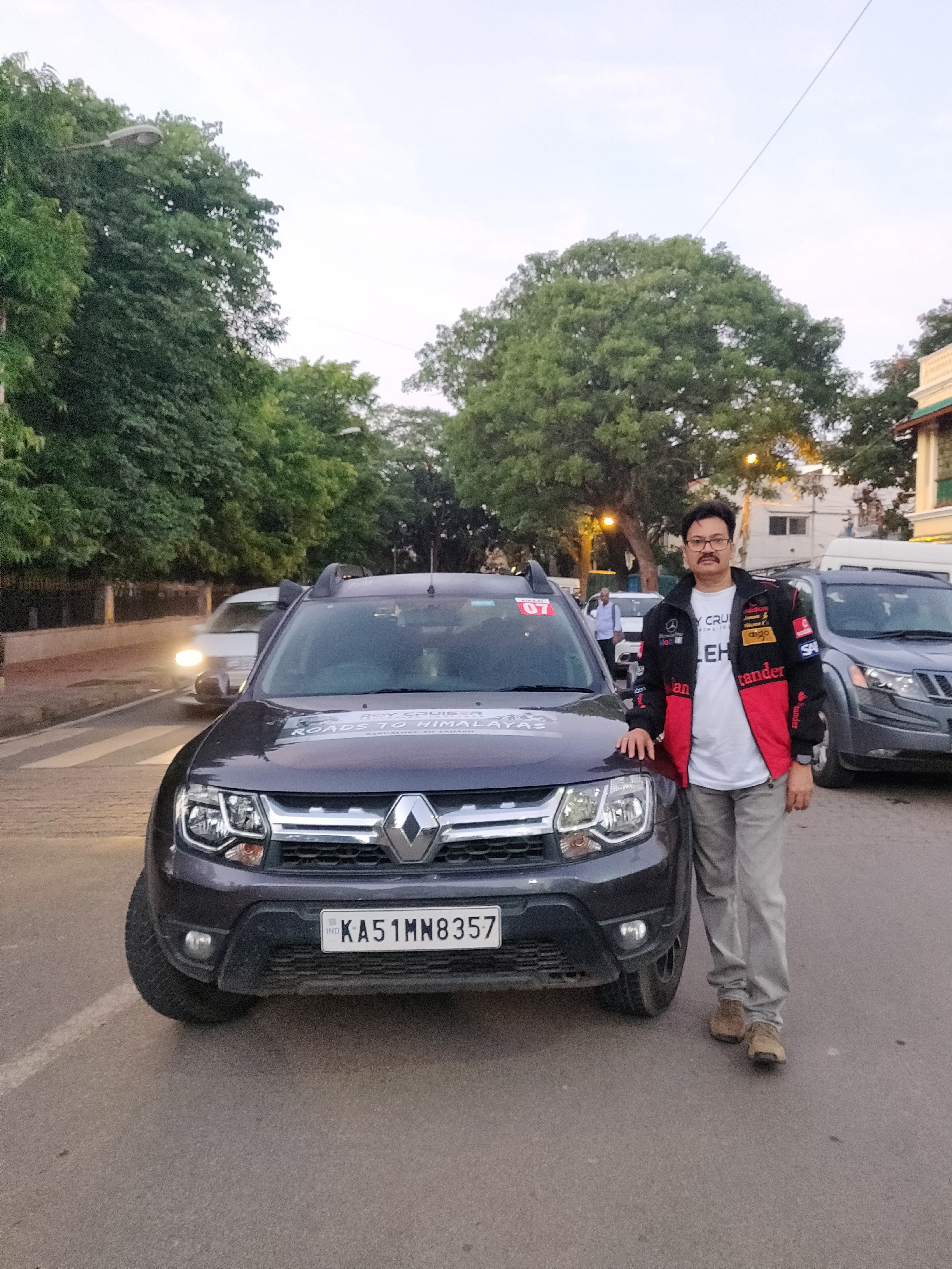
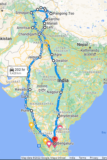
We are embarking on a epic journey, Road to Himalayas by car from
Bangalore to Leh/Ladakh and back. We will be covering 10 States, 2 Union
Territories covering 18 cities. We will be covering around 9500 kms over a
period of 22 days on this Road Trip. This trip is organised by Roy Cruiser LLP.
56 participants and 15 Cars from Bangalore will criss cross the country
and roar in the Himalayas.
We start our Journey on 21 May 2022 and will return on 11 June 2022. Our
Journey starts from Bangalore and will be covering the following places :
1. 1. Pune 2.Kevadia
in Gujarat 3.Jaipur 4.Chandigarh 5.Manali 6.Sarchu 7.Leh 8.Nubra
Valley via Khardungla Pass (one of thee highest motorable road in the world @
17,582 ft) 9.Turtuk 10.Pangong
Tso Lake 11.Leh Via
Chang La Pass, (another highest motorable road in the world @ 17,586 ft) 12.Kargil
via Magnetic Hill 13.Srinagar 14.Amritsar 15.Agra 16.Gwalior 17.Nagpur 18.Hyderabad
I am travelling with my beasty Renault Duster (diesel AMT) and will be accompanied
by my friends Sabitha, Sujatha and Kuldeep in our car and 52 others in 15 cars.
We all met at the Sajan Rao Circle in VV Puram at 5 am. Offered some
pooja and then flagged off at 6.30 am after all the meets, greets & hugs.
There was confusion moving out of Bangalore on to the Tumkur – Pune Highway.
Some got lost including myself and then we all re-assembled at the Nelamangla
Toll gate and regrouped into a convoy.
We stopped at Belgaum for a late lunch and then proceeded towards Pune. We
reached the ghat section at night, but the roads were very good but with a lot
of traffic. Pune looked very impressive at night, the roads/highway were broad
dotted with number of colourful dhabha’s/restaurants on the way.
After a tiring journey of @900 kms we finally reached our hotel well
past mid-night. The reality of a Road to Himalayas trip finally sinked in and
we got a taste of what is in store for us the remaining days.
Day 2
Statue of Unity at Kevadia, Gujarat.
Today we are driving from Pune to the Statue of Unity at Kevdia in
Gujarat.
The Statue of Unity is the world's tallest statue, with a height of 182
metres (597 feet),located in the state of Gujarat, India. It depicts Indian
statesman and independence activist Vallabhbhai Patel (1875–1950), who was the
first deputy prime minister and home minister of independent India and an
adherent of Mahatma Gandhi. Patel was highly respected for his leadership in
uniting 562 princely states of India with a major part of the former British
Raj to form the single Union of India. In Gujarat the statue is found on the
Narmada River in the Kevadiya colony, facing the Sardar Sarovar Dam 100
kilometres (62 mi) southeast of the city of Vadodara
Just in time for sunset and laser show.after a grueling 550 km ride from
Pune and passing through Navi Mumbai, Thane, Vapi and Ankleshwar....so far
travelled 1500 kms . .
Day 3
Kevadia – Udaipur - Jaipur
A gruelling 800+ km drive from Kevadia to Jaipur thro Halol,.Godhra,
Udaipur, Kishangarh and reached Jaipur at 1.20 am. A pit stop for an hour at
Udaipur. Roads were great in the daylight but night driving was dangerous as
there were no lights on the highway or reflectors. Pathetic indifference to
drivers safety on Indian roads at night.
Weather was surprisingly different. Cloud cover kept us cool through the
day but we faced dust storm, hail storm, lightning and thunderstorms at night
which made us drive slow under darkness at night and hence reached late.
Surprisingly many parts of Gujarat the public signboards on the road and
other communications are only in Gujarati and wonder how do others
communicate......
Had an opportunity to vist the Monsoon Palace, also known as the Sajjan
Garh Palace, is a hilltop palatial residence in the city of Udaipur, Rajasthan
in India, overlooking the Fateh Sagar Lake. It is named Sajjangarh after
Maharana Sajjan Singh (1874–1884) of the Mewar Dynasty, who it was built for in
1884.
The palace offers a panoramic view of the city's lakes, palaces and
surrounding countryside. It was built chiefly to watch the monsoon clouds;
hence, appropriately, it is popularly known as Monsoon Palace. It is said that
the Maharana built it at the top of the hill to get a view of his ancestral
home, Chittorgarh. Previously owned by the Mewar royal family, it is now under
the control of the Forest Department of the Government of Rajasthan and has
recently been opened to the public. The palace provides a beautiful view of the
city of Udaipur and the Taj Lake Palace hotel.
Next off to Chandigarh tomorrow.....
Day 4
Jaipur-Chandigarh
Started the day by visiting the Hawa Mahal in Jaipur
Hawa Mahal structure was built in 1799 by the Maharaja Sawai Pratap
Singh, grandson of Maharaja Sawai Jai Singh, the founder of the city of Jaipur,
India. He was so inspired by the unique structure of Khetri Mahal that he built
this grand and historical palace.
It was designed by Lal Chand Ustad. Its five-floor exterior is akin to a
honeycomb with its 953 small windows called Jharokhas decorated with intricate
latticework. The original intent of the lattice design was to allow royal
ladies to observe everyday life and festivals celebrated in the street below
without being seen, since they had to obey the strict rules of
"purdah", which forbade them to appear in public without face
coverings. This architectural feature also allowed cool air from the Venturi
effect to pass throughthus making the whole area more pleasant during the high
temperatures in summer. Many people see the Hawa Mahal from the street view and
think it is the front of the palace, but it is the back.
Then left for Chandigarh via Western Express and the Delhi-Chandigarh
highway. Great roads to drive and reached Chandigarh by 9pm.
Earned a well deserved sleep after 4 days.....
Day 5
Chandigarh - Manali
We are now driving to Manali today. its about 330 km from Chandigarh. We
left at 10.30 am .
Manali is one of the oldest and most popular tourist destinations in
Himachal Pradesh,
With endless views of the breathtaking Greater Himalayas on one hand,
the colorful multi-cultural communities on the other, Manali has become a
popular road trip for many.
The Manali trip from Chandigarh, you will experience the changing
landscape from the cityscape of Chandigarh to the lush farms and fields of
Punjab, finally merging into the higher altitudes of Himachal, and passing
through pine forests and mountains of Himalayas.
Once we crossed Chandigarh city limits and hit the sun-kissed highway,
the world seemed different. The dusty roads bluer skies and endless greenery on
both sides offer a mesmerizing glimpse of Punjab.
We crossed through Rupanagar and then crossed into Himachal Pradesh
where we got the first glimpses of the Himalayas.
it was time to breathe fresh air and some fuel to the body and we took a
break for lunch at the Himalayan Cafe in Bilaspur
The quieter sister of Manali, Kullu is a very popular tourist
attraction. It is more of a valley resort and gives you the taste of the
Himachal life, different than the other towns we had left behind.
We took the National Highway NH3 and is under road widening project.
Half the road is still work in progress and the ride was treacherous and tiring
and gave us a test of off roading experience. But the other half that was
completed was a joy to ride.
When we thought we were there at Manali it took us 45 mins to travel the
last 5 km to enter Manali city and check into our hotel by about 10pm.
Day 6
Rest day @ Manali
A day spent at Manali to recharge ourselves. Also first glimpses of snow
capped Himalays from our room itself.
Manali is a town situated in the northern end of the Kullu Valley, in
Himachal Pradesh & formed by the Beas River.
It is the beginning of an ancient trade route through Lahaul and Ladakh,
over the Karakoram Pass and onto Yarkand and Hotan in the Tarim Basin of China.
Manali is a popular tourist destination in India and serves as the gateway to
the Lahaul and Spiti district as well as the city of Leh in Ladakh.
Preferred to relax today and just took a visit to the Manali town, vana
vihar, lake and the Mall road
Ended evening with some cultural program where local Himachal folk music
and dance was presented. A fun filled evening.....
Off to Sarchu tomorrow.....and the adventure over the toughest terrains
begins ...stay tuned...
Day 7
Manali – Sarchu via Attal Tunnel
We are departing Manali to Leh but with an overnight stay at Sarchu.
On the Manali to Leh route, Sarchu is preferred by most travellers for
night stay. This is where the border of Himachal Pradesh and J&K is
located. Manali to Sarchu distance is approx 230 km.
This is the midpoint in Manali Leh route and took us almost 10 hours to
travel. We passed thro Rohtang, Kelong, Jispa. Zingzingbar, Baralacha.
We drove through the Attal Tunnel which is the longest tunnel 9.4 km in
the world above 10000 ft.
We had our first experience of off roading and passing through river
streams and challenging terrains at Pagal Nala. Many vehicles got stuck and needed
assistance and we took were very nearly stuck and had to switch to manual gears
to get out of the rocky river streams. The most challenging terrain of my life
but memorable.
At Baralacha we had our first experience with snow.
Situated at a staggering height of 14,500 feet above sea level, Sarchu
is nestled on the border of Jammu and Kashmir and Himachal. Surrounded by snow
capped mountains and extraordinary natural beauty.
We reached Sarch by 7pm and the temperature was 1 degree but with wind
chill factor minus 4 degrees. We had to sleep in tents and many fell sick due
to high altitude sickness with vomitting, cold shivers, headache and fever.
i too had cold shivers avnd a severe sinus attack and headche and a
disturbed sleep in the cold tent, covered with two razais and layers of
protection.
That's day 7 a memorable adventure ride and off to Leh tomorrow.....
Day 8
Sarchu - Leh
Today we are riding from Sarchu to Leh. We will have to pass Gatta
Loops,Nakee La & Lachulung La, Pang, Tanglala, More Plains, Rumtse and The
landscape between Lachulung La and Pang is as dramatic as it gets.
The colors varying from white to brown to black to at times even yellow
and pink.
Those high mountains let in just about the right amount of light
creating a play that is simply poetic; especially at that time of the day. The
tiny Lachulung river adds to the charm of the place. The desolateness of it all
making it look almost post-apocalyptic.
the road all the way to Pang from there is just classic. The
anthill-type formations on mountain tops soon become visible. The Grand
Canyon-ish feel of the place simply cannot be ignore
Dramatic scenery is an understatement between Lachulung La and Pang. It
boasts of one of the most inhospitable terrains of the region.
The structures are formed by wind erosion over centuries.
Tanglang la is the 3 rd highest motorable road at an altitude of 17500
ft and was a great and a tough ride on difficult and challenging terrains with
bumpy roads and melting snow water streams on the road
We did reach Leh at around 8pm after passing through magnetic hill where
you defy gravity ....
A challenging day for both man and machine. Off roads,plenty of hairoin
bends, steep slopes, muddy and water strewn roads made it a memorable journey.
Finally we got LEHD .
Day 9
Rest Day - LEH
Today we spend our day in Leh. i chose to relax and not go for
sightseeing as i have already seen it before and was a bit tired after two days
of gruelling drive. I was invited for lunch by my neighbour and friend Col
Rohit Thakur posted in Leh Army HQ almost situated in the lap of Khardungla.
Later in the evening went for a stroll to the Leh market.
Leh is the joint capital and largest city of the region administered by
India as a union territory of Ladakh.
Leh is at an altitude of 3,524 m (11,562 ft), and is connected via
National Highway 1 to Srinagar in the southwest and to Manali in the south via
the Leh-Manali Highway (part of National Highway 3.
The Ladakh capital city of Leh lies near the eastern parts of Jammu and
Kashmir, on the crossroads of the historic "Silk Route" from Sinkiang
to West Asia and to the plains of India. The humbling monasteries of Shey,
Hemis, Alchi, Thikse and Lamayuru will nurture your spiritual needs,
Quite a relaxed day with no driving.......
Day 10
Leh – Nubra via Khardungla Pass
Nubra is approx 150 Kms from the Leh town and takes approx 5 hours
(Including small halt at Khardung la and couple of other places). The road from
Leh to Khardungla was well paved but narrow and with winding roads and hair pin
bends. Its quite a steep ascent to Khardungla.
Khardungla pass is at 5359/18500 ft meters and the amount of oxygen here
is very less. At one point of time Khardungla pass was considered the world’s
highest motorable road but it has lost this place after recalculation of height
by latest GPS technology. There are mostly barren mountains on both sides of
the road till Khardungla pass from Leh, we drove on a narrow road with the high
mountain on one side and the deep valley on another side.
As our car got near the Khardungla pass, the air got thin and I can feel
it while breathing.At this altitude, my lungs were screaming for oxygen and
after the initial excitement of reaching at one of the highest motorable
points, my brain started going dizzy and the cold was making me somewhat numb.
The mountains and valleys on the side of roads were mostly barren but
created a beautiful dramatic landscape with blue sky.
As we moved closer to the Nubra Valley landscape started changing. Now
we were driving on a road, which has a high mountain on one side and a river
fast flowing on the other side. Finally, I saw some greenery after a long
drive. The Yaks and goats were grazing in these meadows. Surrounded by high
mountains Nubra Valley is one of the most fertile regions of Ladakh.
As we came closer to the Hunder village in Nubra valley, the landscape
changed dramatically. There were sand dunes on side of roads and it was very
dusty with swirling dust storms
We visited the Diskit Monastery in Hunder. Diskit Monastery also known
as Deskit Gompa or Diskit Gompa is the oldest and largest Buddhist monastery
(gompa) in the Nubra Valley of Ladakh, northern India.
Diskit Monastery is a major tourist attraction in the Nubra Valley, not
just for its incredible location, but for the 106 feet Maitreya Buddha statue
which is located just below the monastery.
Diskit Monastery in Nubra Valley is situated at an altitude of 10,308
feet, 15 kilometers northwest off the Khalsar-Panakil route, right at the edge
of the desert in the Nubra Valley. It stands atop a hill at the edge of a road,
which links Partharpur & Those.
it offers breath taking view of the Hunder valley especially during dusk
and sunset.
Another gruelling day but with a great sense of achievement having
scaled the 2nd highest motorable road in the world and one of the most
challenging roads to drive.
Day 11
Nubrah – Turtuk via Siachen
Today we are going to Turtuk.
Turtuk, in Ladakh district, is in the Indian-administered part of the
Baltistan region and borders Pakistan's Gilgit-Baltistan area.
Turtuk, is an unknown little hamlet, flanked by Nubra on one side and
Baltistan on the other, lies along the shores of Shyok River. An enigma in
itself, this curious little settlement of ~4000 people is the last northernmost
village before Pakistan – Occupied Kashmir.
Turtuk was part of Pakistan – Occupied Kashmir up until 1971 when Major
Chewang Rinchen got the village under India’s command
Turtuk opened its doors to tourists in 2010.
Turtuk is at the height of 3,001 mt., it is one of the gateways to
Siachen Glacier, making it a strategically important location and is about 205
KM from Leh.
35 KM after Hunder, we stopped at Thoise, a military airfield, and a
tiny settlement. Thoise is an acronym – Transit Halt of Indian Soldiers Enroute
(to Siachen). While no photography is allowed due to the sensitive nature of
the region, the landscapes are exceptionally stunning. We got to hear about the
Siachen war and how our Indian soldiers braved extreme weather conditions and
defended our Indian territory. We paid homage to all those who laid their lives
and also visited the Model living accommodation in Siachen Glacier.
At Turktuk we spent a couple of hours lazing around the river, gazing at
the Himalayas on the Pakistan side and had something to eat before we rode back
home to Hunder in our Tents
The drive was scenic on good roads most of the time. We wound our way
through curvy roads and passed through barren dessert with sprinkled vegetation
and with no signs of civilization for most part.
An interesting day well spent exploring the Nubra Valley.....
Tomorrow we are offf to Pangong....
Day 12
Nubrah – Pangong Tso Lake
Today we are driving to Pangong Tso Lake.
Pangong Tso (lake), is the largest brackish lake in Asia. A large part
of it extends into Tibet. The lake is 80 miles (130 km) long and 3 miles (5 km)
at its widest point. It freezes completely in winter and there's no marine life
here, except for a few migrating birds like gulls and Brahminy ducks.
As this is a border region, the furthest point you're allowed to go to
is Spangmik after which itis controlled by China. You can see some spectacular
views of the mountains of the Changchenmo range to the north, as well as their
reflections in the ever-changing surface of the blue-green lake. Above Spangmik
are the glaciers and snow-capped peaks of the Pangong range.
Pangong Lake is the most gorgeous lake on the planet; that colour of
blue is something you would have only seen in picture books. The road linking
Nubra valley to Pangong lake via Shyok, is certainly one road trip you'll want
to capture extensively.
This place became a very popular destination after the 3 Idiots movie.
More recently it was in the news for Chinese Army incursions into our Pangong
territory but effectively thwarted and defended by our Army. There is heavy
presence of Army all along the route.
The journey from Nubra Valley to Pangong Lake via Shyok is roughly 140
kilometres long. Half the distance the roads are manageable but the other half
is dirt roads, roads under construction and water flowing on roads with rocks
and pebbles strewn along. Its a test of man and machine. With Duster we managed
the trip well driving mostly on manual mode to deal with challenging road
conditions.
We left Nubra around 9 am and reached Pangong at around 5pm.
We were welcomed with freezing temperatures and accentuated by swirling
winds which made it even more colder.
We played around the lake edges, took photographs and then after dinner
tucked into our tents.
The temperature went down to -5 and a real feel of _10 C. We were
worried if the tents on the banks of the lake could insulate us from extreme
weather conditions and more importantly withstand the gutsy winds. However we
managed to have a disturbed sleep and get ready for another challenging drive
back to Leh......
Despite all odds and challenges managed to tick another milestone.....
Day 13
Pangong Tso Lake – Leh via Changla Pass
Today we are returning to Leh via Changla Pass.
Ww assembled one last time at the lake for a group photograph and then
bid goodbye to Pangong lake.
The night temperature was -5 and am sure with the winds blowing the real
feel would have been -10C. i caught severe cold and slight temperature despite
wearing layers of warm clothes.
We drove through Tangtse Village, Changla Pass and Kheru before reaching
Leh.
Changla Pass is another pass used during the Silk Route period. Located
close to 17000feet above ground, the weather changes quickly and we were
fortunate indeed to wotness snowfall at Changla Pass for few minutes.
We had to pass through another Pagal Nala with water streams flowing
through the road and strewn with pebbles and even small rocks.
This was the toughest drive of all days. The roads for most part was
dirt roads and strewn with pebbles, mus roads and water streams passing
through. It was a test of man and machine.
In fact we saw BMW, Thar and Pajero stuck in a few places. Luckily for
us the Duater in manual mode helped us to navigate through these difficult
terrains.
My health started detiorating and temperature risung. Hence I asked Roy
to drive from Changla Pass upto Leh.
We finally reached Leh at 5pm after yet another adventurous day....
Alvida for now and tomorrow we are off to Kargil......
Day 14
Leh - Kargil
Today we are moving to Kargil.
Leh to Kargil highway goes alongside the beautiful Indus River as well
as through certain barren terrains. We rode past Hall of fame, Magnetic Hill,
Sangam, climbed the Namika La, Zozi La, and Fotu La passes located at a greater
altitude. There were breathtaking sights of the untouched landscapes through
the trip. The roads were very good with black tops.
Kargil is the 2nd biggest city of Ladakh and also the joint capital of the
union territory. It is also the headquarters of the Kargil district. Kargil is
located 204 kilometres to the east of Srinagar in Jammu and Kashmir, and 234
kilometres to the west of Leh.
We visited the Kargil war memorial. Kargil War Memorial is a famous
tourist attraction in Kargil. Kargil War Memorial, is a war memorial built by
the Indian Army, located in Dras, in the foothills of the Tololing Hill.
Built in pink sandstone, it commemorates the soldiers of the Indian Army
who lost their lives in the Kargil War.
the winter of 1998-1999, the Pakistan Army crossed the Line of Control
(LoC) and occupied the roads connecting Leh and Kargil to Srinagar, along with
numerous heights along the National Highway.
The Indian Army, in response, launched Operation Vijay (Victory) in May
1999 to retake the territory. Consequently, several fierce battles were fought,
with the Indian Army finally winning the war.
Every year, 26th July is observed as Kargil Vijay Diwas, which means
Kargil Victory Day. The memorial, as it stands today, was constructed by the
Indian Army in November 2014.
At the war memorial we can see major sequence of events which transpired
during the course of the war. A documentary movie is also shown, which explains
the entire war, and the events leading up to it, in detail.
After visiting the war memorial it was so heartening to see how the
Indian Army is protecting us in such difficult terrains and harsh weather
conditions. Hats off to them.....
Day 15
Kargil – Srinagar via Sonamarg
Today we are driving to Srinagar from Kargil.
The journey to Srinagar is about 220km. Along the way we passed by
Kargil War memorial, Drass War Memorial, Zoji La Pass , Baltal Wildlife
Sanctuary, Baltal Valley and Sonamarg.
The road is a mix of good, bad and ugly. The ugliest part is limited
around the Zoji La Pass (11500 ft) For the rest of the distance, the road
remains good or average.
We stopped for lunch at Sonamarg. it was very crowded with hundreds of
vehicles and a few thousand people. The restaurants were full. The snow had
turned black and the snow slides looked unimpressed. So we drove on the
outskirts to a peaceful area by the riverside and enjoyed the scenary and had
our lunch and left for Srinagar.
We come across picturesque landscapes and the roads were dotted with
maple trees which makes the journey more beautiful.
While Ladakh region of Himalays was all rocks, sand and brown in colour,
we saw a dark contrast in the Kashmir region with greenary after a long time.
Srinagar is sometimes called the “Venice of the East”. The city’s lakes
include Lake Dal – known for its houseboats – and Lake Nigeen. In addition to
Dal Lake and Nigeen Lake, Wular Lake and Manasbal Lake are north of Srinagar.
Srinagar prides itself on red apples, orchards, trees of different shapes, ripe
peaches; Everything seems to contribute to Srinagar’s charm.
We reached Srinagar in time for a Shikara Ride on Dal Lake at Sunset. It
was again overly crowded with vehicles on roads and boats on the lake. It was overflowing
with tourists and for most part our Shikara boat was colliding with one or the
other boats and nudging its way around.
We finally settled into our boathouse at the back. A good one with 2
bedrooms, a dinning room and a living room and a veranda which Usher's you into
the boathouse.
I was terribly tired and carrying my illness from Pangong with cold,
sore throat and intermittent fever. Took some strong medication and retired for
bed early.
There was apprehensions about safety and security at Srinagar. But we
had a smooth entry and a safe journey but offcourse with heavy army protection.
Alvida for now and see you tomorrow.
Day 16
Srinagar – Amritsar via Jammu
Today we are driving to Amritsar in Punjab from Srinagar.
Its about 420kms and should normally take around 9-10 hours to reach.
We left at 10.30am and were instantly struck by traffic. Heavy vehicles
and army convoys throughout the Valley. Every time an army convoy passes other
vehicles are stopped.
We passed through Pulwama, Uri, Anantnag, Udampur and Pathankot....do these
places sound familiar?
It took us 10 hours to reach Jammu side and another 6 hours to reach
Amritsar at 3.15 am.
We drove through the Himalayas and wild life sanctuary through the
night. Also were lucky to esacape a landslide on the way
Yet another eventful adventure spent entirely waiting in car or
driving......
Day 17
Rest day – Amritsar
Today is rest day at Amritsar.
We visited the Attari border also known as wagah border and witnessed
the unfurling of the India and Pakistan flags at the International border.
It was quite a experience with temperature at @45 degrees. We had to
drive around 45 minutes and wait in que for about half hour and then a mad rush
to get a vantage point and also shade under the sun.
We had to wait another 2.5 hours before the proceedings began. The BSF
engaged with the audience and kept egging us to outshout our neighbours and
invoking Nationalism and stoking passion.
The final time came and the gates were open and the BSF gaurds exchanged
pleaseantaries shook hands, did some grand standing and finally unfurled the
flags.
In between they called all women and children and asked them to dance to
national music and it was a sight to behold.
A great moment to witness and come close to Pakistan border.
Day 18
Amritsar - Agra
Today we are going to Agra.
The direct drive from Amritsar to Agra is @665 km. We passed by
Ambala, Kurukshetra, Ludhiana, Jalandhar, Ghaziabad, New Delhi
outskirts, Mathura and finally reached Agra.
Due to some missouts and a car getting stuck near the xpress way we
reached late by 2am.
Day 19
Agra to Gwalior
Many of my colleagues visited Taj Mahal and then we left for Gwalior.
Gwalior is about 120kms from Agra is about 2.5hours drive.
We visited the Gwalior Fort in the evening.
Gwalior Fort (Gwāliiyar Qila) is a hill fort near Gwalior, Madhya
Pradesh, India. The fort has existed at least since the 10th century, and the
inscriptions and monuments found within what is now the fort campus indicate
that it may have existed as early as the beginning of the 6th century. The
modern-day fort, consisting a defensive structure and two palaces was built by
Tomaras of Gwalior ruler. The fort has been controlled by a number of different
rulers in its history.
The present-day fort consists of a defensive structure and two main
palaces, "Man Mandir" and Gujar Mahal, built by Tomar ruler(reigned
1486–1516 CE), the latter one for his wife Queen Mrignayani.
The second oldest record of "zero" in the world was found in a
small temple (the stone inscription has the oldest record of the numeric zero
symbol having a place value as in the modern decimal notation), which is
located on the way to the top. The inscription is around 1500 years old.
Also sharing beautiful pictures of Taj Mahal captured by my friend
Sabitha....
Day 20
Gwalior - Nagpur
Today we reached Nagpur after about 700± km ride. The day was spent only
riding.
Day 21
Nagpur - Hyderabad
We visited the Gandhi Ashram at Sewagram in the morning before
proceeding to Hyderabad.
Gandhiji Ashram Bapu Kuti is renowned as Sewagram where Mahatma Gandhi
is believed to have continued the Quit India Movement after 1934.
Bapu kuti is now a well published tourist place where most of people
from foreign tourist who believe in bapu's teaching visit there frequently. It
is nearly 20 km from wardha bus station and railway station as well.
The ashram has a collection of several articles which were used by
Gandhiji when he stayed at this site. In addition to this, the ashram houses
Adi Niwas, Kishore Kuti, Akhri Niwas, Mahadeo Kuti and Ba Kuti. all the houses
are made with the old traditional way using mud. the whole area is well
maintained. there is free entry to visit.
This is indeed a very different kind of place, far removed from one's
day to day experience. One has to visit this place if only for that, to get a
different perspective on things. So serene, peaceful, natural and simple.
We had a sumptuous satvic lunch at the Ashram and then left for
Hyderabad. Another 500+ km ride and made it to Hyderabad by 7pm. The last 1
hours drive was in bumper to bumper traffic.
We have reached the penultimate day and look forward to returning home
to Bangalore tomorrow......
Day 22
Hyderabad to Bangalore
It was a nostalgic day as it was the last day of our trip but at the same
time all of us were eager to return home in Bangalore after a gruelling 22 day
trip.
After breakfast, greet & meets and hugs, all of us jumped onto our
cars and started our last leg of our journey.
We all met at Anantpur for a late lunch and finally reached Bangalore
(Bangalore International Airport) by about 6 pm. There after it took me about
2.5 hours to reach home after dropping my car mates Sabitha & Sujatha on
the way. After being used to cruising at 100+ km speeds it was frustrating driving
bumper to bumper the last couple of hours.
Conclusion
The Trip was organized by Roy Cruisers.
It was a memorable trip and helped fulfill our long cherished dream of
self driving on the Himalayas. We drove through highways, deserts, hills,
mountains, dirt roads, snow, pebble roads, river crossing, dust storms etc and
it was a test of Man and Machine and also Physical & Mental endurance. Its
not for the faint hearted but as Evazubeck says “the
world belongs to the brave”.
I strongly believe that age is only a number. I drove almost around
6500km and my friends shared the remaining with the bulk being driven by my
friend Ms.Sabitha. Yes the thought of embarking on a 9000km journey across 15
states and spread over 22 days is daunting but when you are passionate and love
to drive on challenging terrains and explore the world, its no more stressful.
Its not the absence of fear, challenges, stress but it’s the conquest of
fear, challenges and stress that differentiates between a successful person and
the not-so successful person.
Yes every day I used to get up at 5.45 am, get ready by 7 am and get
ready for a long challenging drive. We reached our destination many a times in
the night as late as 3.30 am at Amritsar. We drove through mountains, forests
and other challenging terrains at night with near zero visibility. We faced
dust storm, hail storm, snow and other challenges thrown at us by mother
nature.
My body was pushed to the limits. 66 different breakfast, lunches,
dinner and water. The temperature at Pangong Lake was -5 (actual feel -10C
because of wind) and in 4 days we were in Amritsar with temperature soaring to
47degrees.
By Gods grace I managed to pass through the ordeal and but for some cold
& cough & feverishness for a few days nothing to cry about.
Every day we thought that we had faced the toughest road and challenges
only to realise that the next day was even tougher.
If we thought that day1 – Bangalore to Pune @900km was tough, the ride
to Kevadia was even tougher, navigating through Navi Mumbai. The next day to Jaipur
was even tougher, the route from Manali to Sarchu was tough with Pagal Nala, dirt
roads, water streams, snow clad roads etc, but the next day Sarchu to Leh was
even tougher having to climb the dreaded 21 Gatala Loops and ride past
Khardungla. If we thought we had conquered the 2nd highest motorable
road in the world, we found that the route was even tougher.
We passed through some of the highest motorable passes Kardhungla Pass,
Changla Pass, Tanglang Pass, Bara Lacha La Pass, Fotu La Pass, Zoji La Pass and
each one of them were tougher than the previous one.
We passed through various sensitive areas across the border Turktuk,
Siachen, Tiger Hill, Drass, Kargil, Srinagar, Pulwama, Anantnag, Udampur &
Pathankot but never felt unsafe. Offcourse there was sporadic presence of Army
men deployed in some of these sensitive areas.
If we thought we were done with Himalayas with Srinagar, we were in for
a rude shock. The journey from Srinagar to Amritsar was the toughest one and
took almost 16 hours to reach about 450 kms. Heavy army convoy movements, narrow
roads, roads under construction, landslides and heavy vehicular movements
towards Jammu made us move bumper to bumper for most part of the journey. And when
we thought we had climbed the highest peak and were climbing down, another peak
to scale and we had to scale a wave of mountains and curvy roads before passing
through a National Reserve Forest near Udampur at mid-night.
Roy & Rohit from Roy Cruisers and Jaideep & Munish from
Himalayan Panthers did a great job in planning the itinerary and coordinated
all the arrangements to ensure that the large convoy and participants
successfully complete the trip and return back safely.
There was not a single incident of safety or accidents for all the 15
cars and 58 participants. My car did not have a single dent or even a puncture.
The accommodations were good and the safety back up was very assuring.
Roy & the team were ever ready to help us in distress even in midnight.
They were very supportive, worked tirelessly, took some flak but yet retained
their composure and were always with a smile.
I drove a Renault Duster, Diesel Automatic and should say that it was
very reliable and efficient. Except for high altitude mountains (where there
was power loss due to low oxygen), the beast sailed through most difficult
terrains with full load (4 passengers and dicky packed to the brim with
luggage’s). I had to shift to manual mode a few times during these challenging
high altitude places but other wise cruised in auto mode. It’s a very reliable
all terrain SUV. No wonder the Renault Duster is a popular SUV world over.
Met a lot of people, made new friends and will truly cherish this trip
in my life and also look back with a feeling of accomplishment……
I would like to thank my friend Ms.Sabitha who was a constant source of
support and who pitched in to drive in challenging circumstances and share my
load.
I would also like to thank my fellow car mates Sujatha, Kuldeep for
their support during the journey. Would also like to thank my room mate Vasanth Kumar
who treated me like an elder brother and helped me with my luggages and other
arrangements.
I would like to also thank all my fellow drivers who lent their support
and encouragement to other participants. There were moments of high and low and
in all this, we felt like one family. Without their support, it would not have
been possible to complete this arduous journey.
I will be failing in my duty if I don't thank Sahana Ranjan
& all of my family members, friends and well wishers who kept following my
journey, encouraged me and motivating me. Thanks for all your kind wishes and
words of encouragement..........


.jpg)

.jpg)
.jpg)